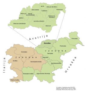
Koroška is located in the northern part of the Republic of Slovenia at the boundary of the Southern and the Central Alps. It consists of 12 municipalities: Črna na Koroškem; Mežica; Prevalje; Ravne na Koroškem; Mislinja; Dravograd; Muta; Vuzenica; Radlje ob Dravi; Podvelka; Ribnica na Pohorju, and Slovenj Gradec. The latter is the only one in the region with the status of an urban municipality.
With the area of a little over 1,000 km2 and almost 72.000 inhabitants, Koroška is one of the smaller Slovenian regions. The centre of the region consists of the Slovenj Gradec, Ravne na Koroškem, and Dravograd “conurbation”. Dispersed settlements are typical for Koroška’s rural hinterland. The farms are surrounded with the adjoining farmland and dispersed throughout the entire region. Specific regional characteristics are: large areas covered in forests; a dense river network, and the concentration of businesses in urban settlements in the valleys (the Meža, the Mislinja, and the Drava valleys). One of the particularities of the region is also an almost 100-km long frontier with the Republic of Austria, with 8 municipalities directly bordering the neighbouring country.
Koroška is one of the oldest Slovenian industrial regions. In the previous centuries, the mining industry had been developed in the area, with mining possibly already being active in the Roman Age. After that, iron making and the wood industry became prominent here, with the metal processing industry, component manufacture for the automotive industry, as well as mechanical engineering thriving in the recent years. These manufacturing industries still prevail in the regional economy, which is distinctively export-oriented.
In the field of education, the region is suitably ensured with a network of schools and kindergartens. The accessibility of secondary-school programmes is suitable. In the recent years, post-secondary and higher-education programmes have also been established in the region.

The entire region of Koroška is identified as an area with limited possibilities for farming. Because of its steep slopes and high altitudes, the region falls within the hill and mountain areas.
According to the data provided by the Ministry of the Environment and Spatial Planning, the region is covered with 27 % of the Natura 2000 areas. Among these are also areas within the Karavanke Geopark, the Pohorje Hills, and areas along the River Drava.
The Koroška region is facing development problems. In comparison to other regions, all indicators show that Koroška is below the Slovenian average (with the exception of a relatively young but rapidly ageing population). The region is increasingly falling behind the most developed regions, and according to the development risk index, it is in 8th place out of 12 Slovenian regions.
On the basis of its own development potentials, the region seeks opportunities in the development of existing activities, as well as new, environmentally-friendly activities with a higher value added (particularly in the further development of the metal processing industry, the automotive industry component manufacture, the development of the wood-processing industry, tourism, and food self-sufficiency).
The Koroška region’s vision by 2020 istobecome (as well as remain) an economically successful and a socially and spatially connected community, encouraging creativity, entrepreneurship, openness, and inclusiveness of everyone, while enabling its population to enjoy a high quality of life, healthy and safe working conditions, clean environment, and a sustainable management of natural resources.
Selected Indicators:
| Koroška | Slovenia | |
|---|---|---|
| Area km2 | 1.041 | 20.273 |
| Population 1. 7. 2013 | 71.945 | 2,059,114 |
| Population Density (No. of Inhabitants/km2, 1. 7. 2013) | 69.1 | 101.6 |
| Number of Municipalities | 12 | 212 |
| Average Age of Population | 42.5 | 42.2 |
| Ageing Index (1. 7. 2013) | 120.5 | 118.9 |
| Total Increase of Population (2012) | -268 | 3.325 |
| GDP/capita (in EUR, 2013) | 13.673 | 17.172 |
| Value Added per Employee in Companies (in EUR, 2011) | 33.186 | 37.512 |
| Number of Working Population (2012) | 27.356 | 792.948 |
| Registered Unemployment Rate (2013) | 2021-09-13 00:00:00 | 2021-01-13 00:00:00 |
| Average Gross Wage (in EUR, 2012) | 1.465 | 1.601 |
| Difference Between Men's and Women's Average Gross Wage (in %, 2012) | 4.0 | 2021-01-05 00:00:00 |
| Number of Companies (2012) | 4.659 | 161.636 |
| Companies Revenue (in 1,000 EUR, 2012) | 2,020,239 | 90,739,422 |
| Gross Fixed Capital Formation (in Millions EUR, 2012) | 122.4 | 4,824.9 |
| Number of Employees in Research and Development Activities (2011) | 275 | 21.548 |
| Number of Tourists' Overnight Stays (2013) | 112.964 | 9,579,033 |
| Share of Agricultural Holdings Dealing with Organic Farming (in %, 2010) | 2021-11-10 00:00:00 | 2021-09-07 00:00:00 |
| Share of the NATURA 2000 Areas (%) | 27 | 37.16 |
| % Areas Covered in Forests | 68 | 58.4 |
| Number of Graduates per 1,000 Inhabitants (2013) | 1999-09-01 00:00:00 | 2021-11-09 00:00:00 |
| Number of Inhabitants Aged 20 Years and Older per Doctor in General/Family Medicine (2012) | 1.71 | 1.685 |
| Share of Children in Kindergartens (in %, 2013) | 68.8 | 74.9 |
| Number of Occupants in Residential Homes for the Elderly per 1,000 Inhabitants (2013) | 2021-03-09 00:00:00 | 2021-04-09 00:00:00 |
| Length of Motorways in km (2012) | - | 675.2 |
| Consumption of Water from the Public Water Supply in Households (m3/Inhabitant, 2013) | 2021-01-29 00:00:00 | 38.2 |
| Produced Urban Waste (kg/Inhabitant, 2013) | 327 | 414 |